 - Floodprone land")
 - Floodprone land")
 Hazard Profile")
 Hazard Profile")


If the situation is life threatening you should call 000.
Never walk, ride or drive through flood waters.
For other assistance during an emergency such as flood, storm or tsunami, please contact the NSW State Emergency Service (SES) on 132 500 or visit their website at www.ses.nsw.gov.au.
It is best to be prepared for any flood. The State Emergency Service provides advice on how to manage your flood risk at https://www.ses.nsw.gov.au/flood-awareness-nsw/
The City of Parramatta is one of the most flash-flood affected areas in the state. We know our flood risk is high and over the years we’ve taken action to manage flooding and support our community – we can’t stop floods happening, but we can work together to make sure everyone stays safe.
Various teams across Council work on flood modelling and ensure planning and development considers flooding. Other teams design, build and maintain infrastructure to manage the risks of flooding and minimise the impact of flood water including upgrades to our stormwater systems.
In terms of raising awareness around flooding and supporting the community, we’ve worked closely with partners including NSW SES and Sydney Water to create the award-winning FloodSmart Parramatta service. This service recently expanded and now monitors 10 areas across the LGA providing early flood warnings to our community and advice on preparing for a flood. In heavy rains we saw more than 1000 new subscribers to this free service.
Council is also part of the Parramatta Local Emergency Management Committee (LEMC). The LEMC, involves combat agencies such as the NSW Police, SES, Fire & Rescue NSW. Together, we support the prevention of emergencies, and prepare for and respond to various events including flooding. The LEMC also assists the community in recovery and clean-up operations.
Learn about FloodSmart and watch a short video here.
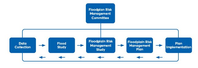
Councils prepare Flood Studies and Floodplain Risk Management Studies and Plans in accordance with the NSW Government's Floodplain Development Manual (2005). Associated recommendations are generally implemented with the technical and financial assistance of the NSW Department of Planning and Environment.
Following the Flood Study, City of Parramatta will work towards a Floodplain Risk Management Plan which details the recommendations to reduce the impacts of flooding to residents and businesses in the study area.
For more information on what else Council is doing to reduce the risk of flooding see https://www.cityofparramatta.nsw.gov.au/environment/connected-resilient-communities/flooding
Sydney Water owns and manages the operation and maintenance of its trunk draining channels and partners with City of Parramatta on a number projects including the award winning FloodSmart early-warning program. The responsibility of flood modelling and floodplain risk management is the responsibility of councils. As an important stakeholder Sydney Water has reviewed the modelling and will continue to work with City of Parramatta.
The NSW Government requires that local councils manage the risk of flooding within their Local Government Area (LGA). More details about these requirements can be found at environment.nsw.gov.au/topics/water/ floodplains/floodplain-guidelines.
A flood study, along with data collection, is the first step in understanding the flood risk in a LGA. It is a technical investigation of flood behaviour from small floods up to the largest possible flood.
A flood study allows council to identify the risks from different sized floods across the LGA. This helps in managing buildings and other Council assets and in planning for future development.
The flood study not only looks at the current flood risk but also future flood risks including those that may result from climate change.
Following NSW Government requirements, City of Parramatta began working on the draft flood study in late 2015, appointing leading flood consultancy Stantec (then known as Cardno) to the project.
Parramatta’s flood model is one of the largest urban flood models in the state, dealing with complicated hydrology and flood hydraulics.
Throughout its development, the Draft Flood Study was independently peer reviewed four times by WMA Water - prior to being placed on public exhibition.
Following review of public submissions, adjustments to the Draft Flood Model may be made. It will then proceed to Council for adoption.
The next steps will be the development of a Floodplain Risk Management Study and Plan, which will both be open for community consultation.
There have been several previous flood studies completed in the City of Parramatta LGA. However, the existing flood studies do not cover all of the LGA and do not model all types of flooding.
The NSW Government requires Council to carry out a comprehensive flood study into all types of flooding across its LGA using current flood modelling techniques.
Most of Council’s current flood studies are based on mainstream flooding from rivers and creeks. There has been no flood study to date that examines flooding that can come from local stormwater drains and from the local overland catchment.
There are also several parts of the LGA that have not had a flood study. These areas include the upper reaches of the catchments that represent local overland flow areas.
Modelling of the local catchment system, including overland flooding, is the key to improving Council’s existing flood information. As flood modelling techniques have been updated, new technologies provide us with the ability to more accurately determine the hydraulic flood conditions within the catchment area.
A new flood study will provide the opportunity to use new 2D flood modelling software such as TUFLOW to better determine hydraulic flood conditions. It should be noted that while most of the LGA is included in the new flood study, there are remaining sections will be studied separately.
The current draft flood study has taken five (5) years to produce. This is due to several reasons including:
- The complexity of the flood model, which is one of the most sophisticated ever developed in Australia
- The review of all previous flood studies and the need to identify changes that have occurred within the catchments due to growth in population, changes to buildings and development across the LGA.
There are several benefits provided by the new flood study including:
- provides Council with an understanding of flood risk across the LGA so it can manage existing development and plan for future development
- helps emergency services (e.g. NSW State Emergency Services [SES], Police) understand the impacts on people’s safety when various levels of flooding occur
- helps landowners to understand their flood risk so they can be better prepared for flooding.
The Probable Maximum Flood (PMF) combines a range of extreme conditions and probabilities to calculate the largest flood that could possibly occur within a catchment. It is rare and is calculated to understand the full risk of flooding. The PMF is also used in the design of critical and sensitive facilities such as hospitals, childcares, nursing homes, schools and emergency service facilities.
A 1% AEP (annual exceedance probability) flood is a flood event of a size that has a 1% chance of occurring at a particular location in any given year. This used to be known as a ‘1 in 100 year’ flood a term which can be misleading. Some parts of Australia have experienced more than one ‘1 in 100 year’ flood within a decade. Within the Flood Study the ‘1 in 100 year’ flood is referred to as the 1% AEP flood event.
Work on the Draft Parramatta River Flood Study Area began in late 2015, prior to the Council amalgamations. There are separate flood studies planned for other areas. Work began last year on the A’Becketts Creek Flood Study, and Wentworth Point will be covered under a separate flood study, as part of the Masterplan for Wentworth Point. Work on the Wentworth Point Masterplan is expected to begin in 2024 and the results of that study will be included in a separate consultation with the Wentworth Point community once this work is completed.
Yes. The flood study has identified several thousand extra properties that we did not previously know were flood affected.
Most of these properties will only be very rarely affected by flooding, but knowing where flooding could occur will allow City of Parramatta Council to take actions to reduce or eliminate the risk of flooding to these properties.
Approximately 7,581 parcels of land have been newly-identified as at risk of flooding.
It should be noted that some of these properties have a very low risk of flooding. However, there are several that will receive relatively regular, potentially dangerous flooding.
For most people, there is nothing to do in response to this Draft Flood Study other than know their flood risk and take appropriate actions for flood planning. However, property owners who are planning redevelopment of their property may need to appropriately consider the impacts of flood risk during the development process. If properties are identified as flood-affected there could be requirements including having the floor levels of the development set at or above the Flood Planning Level. This ensures that the impacts of flooding are reduced. If you’re planning changes to your property and it is flood-affected contact Council’s planning department.
Your property may be at risk of flooding. You may know this from previous flooding. However, due to drought conditions and other factors, there are many parts of the LGA that have not recently experienced large flooding events and therefore landowners may not be aware of their flood risk.
You can also learn more about flooding and register for flood alerts at Council’s FLOODSMART here.
The flooding from the stormwater system can be difficult to imagine in comparison with flooding from a river or creek where the level of water is easily seen. However, this type of flooding which is called ‘overland flow’ can be dangerous as it usually rises quickly after local heavy rain e.g. thunderstorms.
It is important to understand that properties now considered to be at risk of flood (flooding detected in the new flood model) have always had a flood risk.
All properties at risk of fooding will now have flood risk noted on their property certificates.
Simply putting a “flood risk notification” on an individual property does not typically affect house prices. House prices are largely based on the size and presentation of the house itself, demand from people wanting to live in the area, and the economic conditions at the time of sale.
Members of the public can contact Council to raise flood related issues. You can provide comments on the 2023 Draft Flood Study by providing feedback via Participate Parramatta. You can also contact our flood team via phone, pre-book a meeting, or by emailing Council at FloodSmart@cityofparramatta.nsw.gov.au.
The insurance industry already has a good understanding of flood risk across the LGA and property insurance premiums are set accordingly. The new flood study will provide the insurance industry with a more refined understanding of flood risk, which in some cases may affect insurance premiums.
All landowners with properties at risk of flooding should consider flood insurance and discuss this with their insurance provider.