The shared path on the southern side of Epping Road was completed in 2021.
To fill in a missing link of the cycling connection between Macquarie Park and Carlingford via Epping, City of Parramatta constructed a 3.0m wide shared path for the use of pedestrians and cyclists on the southern side of Epping Road, between Pembroke Street and Blaxland Road, Epping. A copy of the detailed plans is available in the 'Shared Path on Epping Road Resources' section.
Following community consultation in 2020, the proposal was put to Council's Traffic Committee and approved on Thursday 5 November 2020. The proposal was endorsed by Council at its Meeting held on Monday 7 December 2020.
The new 3m wide pedestrian and cyclist bridge on the western approach to Terrys Creek on the southern side of Epping Road was opened in late 2022. The former bridge did not meet current standards for shared pedestrian and cyclist use, nor community expectations.
- Council appointed Fleetwood Urban to deliver the new 3m wide bridge and approach paths.
- The alignment just upstream of the existing bridge was selected to minimise the impact to vegetation, it also allows the current bridge to be used whilst the new one is under construction.
- Two smaller native trees were removed, 4 tree ferns transplanted, and great care taken to minimise any impact to other trees in close proximity.
The Midson Road Refuge Island upgrade was completed in 2021.
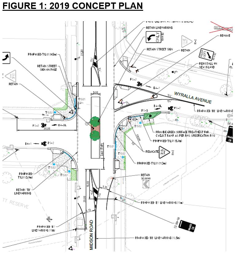
City of Parramatta installed a pedestrian and cyclist refuge island in Midson Road at Wyralla Avenue, Epping, along with small sections of shared user path as per the concept plan accessible in the 'Midson Road Refuge Island - Resources' section.
Following community consultation in 2020, the proposal was put to Council's Traffic Committee and approved on Thursday 5 November 2020. The proposal was then taken to the Council Meeting held on Monday 7 December 2020, where it was resolved that the project would be delivered.
Previously, Council advertised the extended refuge island shown in Figure 1. The key concerns raised during consultation were the scale of concrete and the undesirability of restricting right turns in this location. Therefore, a scaled down island is now proposed that does not restrict right turns, and shared paths are on the southern side only.


A refuge island allows people to cross a road in two stages. On a busy road like Midson, it makes it easier to cross as someone only has to wait for a break in traffic from one direction.
The Melaleuca on the north eastern corner that was proposed to be removed is now retained, however the Brushbox identified in Figure 3 will need to be removed. An independent road safety audit identified that someone standing on the David Scott Reserve corner crossing to the east would not be able to see the oncoming northbound traffic (and vice versa) from an adequate distance.
In close proximity, locations have been identified to plant 8, 75L (4m) mature Brushbox trees to offset this loss.


