Project Update - August 2025
At the Rosehill Ward Meeting on Wednesday 13 August 2025 it was agreed to take the following steps in relation to the implementation of further traffic management options such as one-way streets and other possible parking permit schemes.
Regulatory Services and Traffic & Transport Services will:
1. Monitor traffic and parking conditions in Newington on major event days in the next 3 to 6 months.
2. Allow residents to experience the impact of the new No Parking and No Stopping restrictions.
3. Use this information to guide future decisions on additional traffic management options (One Way restrictions, Special Event Parking Scheme and Resident Parking Scheme) in early 2026.
BACKGROUND
Newington is primarily a residential area which is located within 2km walking distance from Sydney Olympic Park (SOP). Many streets in the area are narrow and access can become restricted when cars are parked on both sides. This issue is especially pronounced during major events at nearby Sydney Olympic Park, when event attendees make use of the local street parking. It poses a particular challenge for emergency vehicles, which require a minimum 3.5m travel lane in width.
Between April and May 2025, Council consulted the Newington community on various proposals to address the ongoing parking and access issues. To improve safety and ensure reliable emergency access, Council proposed to implement the following parking restrictions in streets identified as more likely to experience these issues:
- Introduction of ‘No Parking’ restrictions on one side of selected streets to maintain a minimum 3.5m carriageway (or 3m on streets that are 5m wide)
- Introduction of ‘No Stopping’ restrictions at bends and intersections to allow vehicles to safely navigate the area
Over half of the community feedback was supportive of the measure, with many residents requesting that additional streets, beyond those originally proposed, be included in the plan. Please read the Frequently Asked Questions section further down this page for more information on this stage of engagement and Council's response.
Current consultation closing 5pm on Monday 25 August 2025
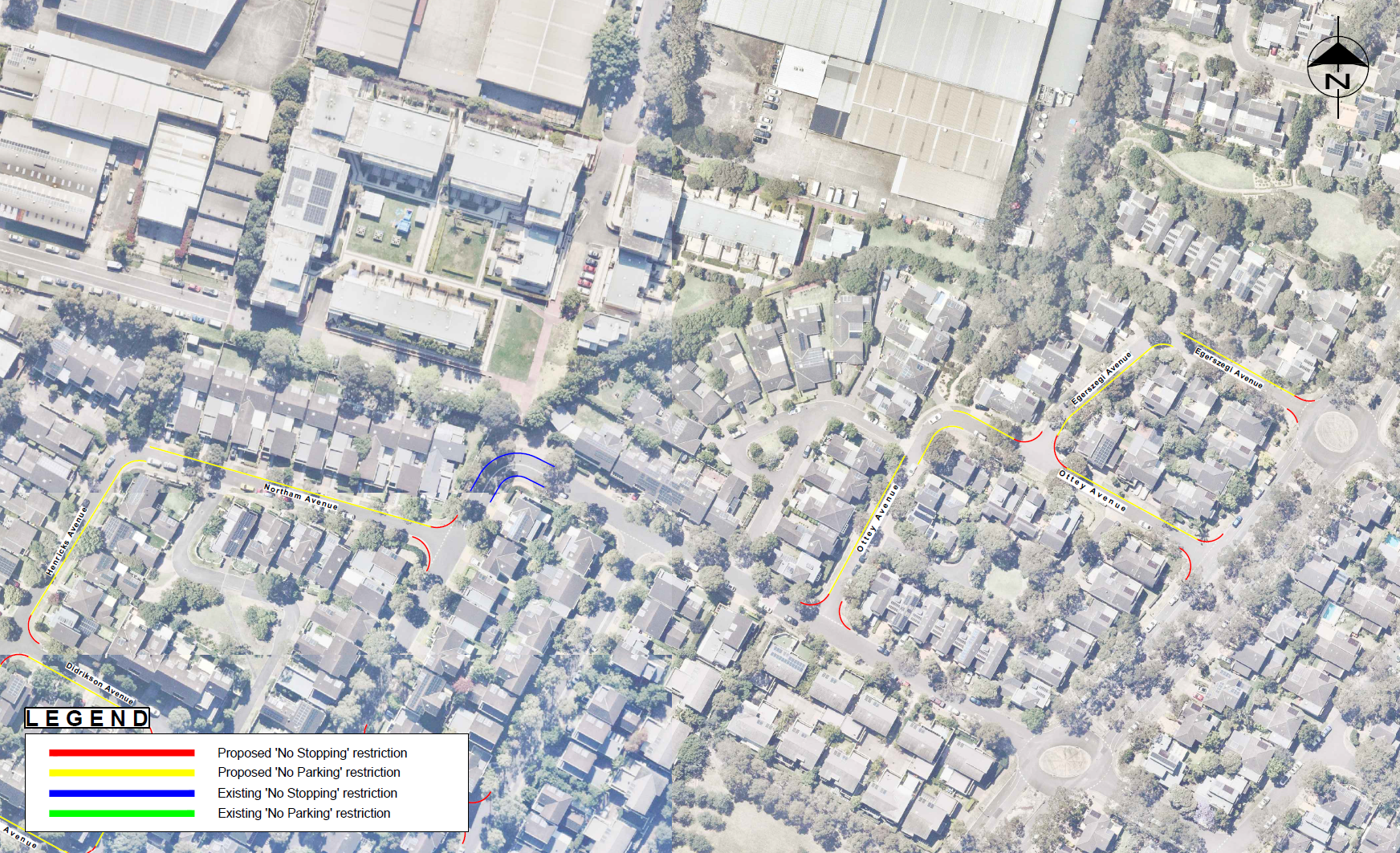
As a result of the additional requests, Council is now proposing to extend these changes to further narrow streets within a pocket of Newington, located southwest of Wing Parade, Newington Boulevard, and Egerszegi Avenue.
 Map 1: Additional proposed streets for introduction of 'No Stopping' and 'No Parking' restrictions
 Map 2: Additional proposed streets for introduction of 'No Stopping' and 'No Parking' restrictions
 Map 3. Additional proposed streets for introduction of 'No Stopping' and 'No Parking' restrictions
To download a larger version of the maps, please see the RESOURCES section.
Please note, while some streets in Newington are narrow, they may not be significantly impacted by event-related parking and can generally maintain travel lanes between 3.0m and 3.5m in width. In these cases, parking restrictions may not be necessary. If residents request it, Council will consider excluding these streets from the proposed changes.
Have your say
Council is seeking input regarding this proposal and inviting submissions from residents, businesses, and relevant authorities. Have your say by completing the online submission form. For other ways to get involved including via email, post, or verbally, please scroll down the page.
Submissions are welcome until 5pm on Monday 25 August 2025.
Next steps
Following the public exhibition, all submissions will be reviewed and considered, before a decision is made on whether or not to proceed with the proposal.
To stay updated on the progress of this project, please FOLLOW this page.


