The NSW Government requires that local councils manage the risk of flooding within their Local Government Area (LGA). More details about these requirements can be found at https://www.environment.nsw.gov.au/topics/water/floodplains/floodplain-guidelines
Collecting information is the first step in understanding local flood risk (this project). Flood Studies then move to preparation of a flood model and community consultation around the flood maps generated as part of the study. The final stage is a Floodplain Risk Management Study & Plan where mitigations and potential works are considered.
A flood study looks at the current risk and also future flood risks including those that may result from climate change.
Council will use the information it gathers as part of this project to create flood models capable of predicting water movement in various sizes of flood, from smaller rainfall events up to the probable maximum flood (PMF) level.
It is expected that the community will be invited to provide feedback on the Haslam Creek flood model in mid-2025.
There have been several flood studies completed in the City of Parramatta. However, this will be the first flood study carried out by City of Parramatta Council for the Haslams Creek area.
Updated flood modelling guidance and techniques, as well as new technology, allows the City of Parramatta to predict flood extents, potential hazards and risk for a wide range of flood levels from small rainfall events up to the probable maximum flood (PMF) level.
New flood modelling technology and techniques will also allow City of Parramatta to investigate, and model, flooding from stormwater drainage and overland flow i.e. water that travels across fields, adjacent property, roads etc in addition to water which originates from overflowing creeks and rivers.
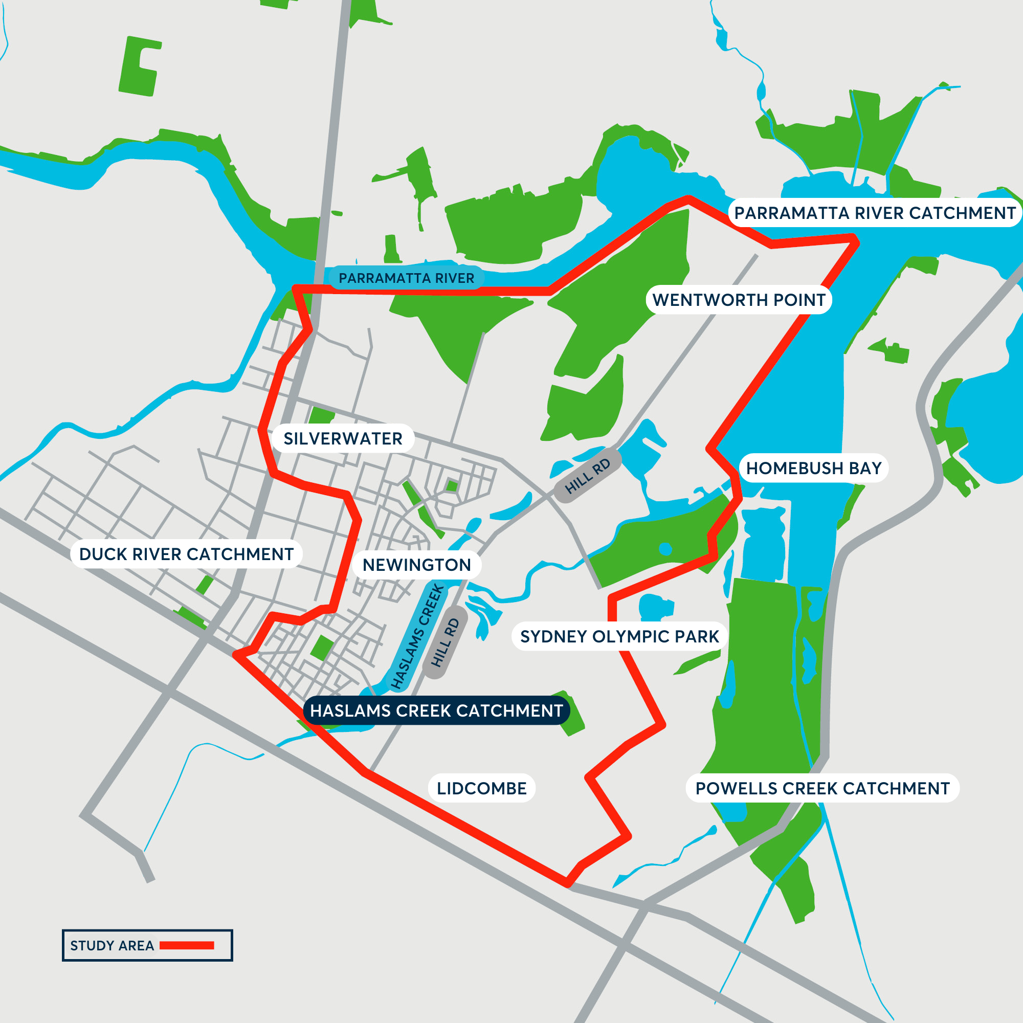
The Haslams Creek flood study will also support the work required to upgrade Hill Road. For many years, Council has been advocating for increased resources to manage flooding around Hill Road to reduce road closures during storm events and to provide our community with safer access to areas including Wentworth Point, Carter Street and Lidcombe.
This flood study will help inform potential solutions to flooding on Hill Road. For more information on the Hill Road project see the brochure in the Resources section on the right of this page.
Benefits provided by the new flood study include:
- Providing Council with an understanding of flood behaviour across its catchment areas to reduce flood risks for existing and future development
- Helping landowners understand their flood risk so they can be better prepared for flooding.
- Helping emergency services [e.g. NSW State Emergency Services (SES) and Police] understand the impacts on people’s safety when various levels of flooding occur
- Providing FloodSmart Parramatta the information it needs to provide your community with flood warnings.
FloodSmart Parramatta is a free service for the Upper Parramatta River within the City of Parramatta local government area. FloodSmart Parramatta provides early warning about flooding and was created by Council in partnership with Sydney Water and the NSW Government to help protect homes and businesses that could be affected by flash flooding or flood.
Flash flooding is flooding that occurs very quickly and can lead to rapid rises in water level. Large floods are rare, but even small floods can cause damage and disruption.
FloodSmart aims to provide communities, individuals, and business owners with vital information to understand flood risk in their area. Knowing if you are at risk, how to prepare and what to do in a flood will help keep the community safe.
From late-2024, the FloodSmart service will expand to cover 14 monitoring sites across the Local Government Area providing early warning information about flood conditions in real time to subscribers.
Residents and business owners in the Carter Street Precinct, Hill Road Precinct, Lidcombe, Silverwater, Sydney Olympic Park and Wentworth Point will be able to receive free flood warnings and updates via SMS, email or voice message.
Council will provide more information on how to subscribe once the monitoring system for Haslams Creek has been tested and is live.
Visit Floodsmart for more information on the FloodSmart Service (currently monitoring ten sites, expanding to include Haslam Creek in late 2024).
Collecting information from residents and beginning technical studies is the first step in the NSW Government’s three stage Floodplain Risk Management process.
Following data collection (this stage), Council’s specialists will undertake flood modelling which seeks to map the flow of water, identify potential hazard areas, and forecast depth of floodwater under different size flooding events.
The flood model will be peer reviewed and once approved by Council will be shared with the community for feedback. The Draft Haslams Creek Flood Study is expected to be on public exhibition in mid-2025.
Following assessment of stakeholder and community feedback, further adjustments will be made to the study if required, with the final draft provided to Council for endorsement.
Once the 2025 Haslams Creek Flood Study is endorsed, the final stage of the process will begin with Council starting work on the Floodplain Risk Management Study and Plan. This piece of work will investigate and identify appropriate flood mitigation actions that can be delivered to reduce or resolve flooding in areas with a high flood risk.
When completed, the Draft Haslams Creek Floodplain Risk Management Study and Plan will be presented to the community for feedback. Following assessment of feedback and any modification, it will then proceed to Council for endorsement before being lodged with the NSW Government.
Receiving or participating this survey does not mean your property is flood prone or will be identified as flood affected.
However, you can find out about your specific property’s flood risk by requesting a flood enquiry application pack or by visiting the Council’s website and choosing the appropriate flood application for your circumstances.
To do this, click this link https://www.cityofparramatta.nsw.gov.au/ and follow the steps.
1. Make a request on the homepage
2. Lodge an application.
3. Then click on the appropriate flooding application for your circumstances (Residential, Duplex, Commercial, etc.)
Or call the City of Parramatta Customer Contact Centre at 1300 617 058 and ask to speak with the Flood team.
When rain falls, it finds the quickest way to the river, sometimes this means going through normally dry land or along roads and paths. If the amount of water is higher than the usual capacity of the route, or debris blocks one of these routes it can cause flooding at a local level that is not expected.
This often happens when a lot of rain falls in a very short amount of time overloading our drains and stormwater systems, or if the ground is very wet already and further rain falls.
In areas such as Wentworth Point, there are some additional factors which lead to frequent flooding of Hill Road and other areas, such as high water levels in the Parramatta River.
There are many contributing factors to flooding in Wentworth Point and in the Carter Street precinct particularly on Hill Road.
Wentworth Point and Carter Street are some of the most highly populated areas in our Local Government Area and in the State. With high-density living, a rapidly increasing population, a lot of hard surfaces impervious to water, and in Wentworth Point and Carter Street not much green space to absorb or slow floodwater, managing flooding becomes increasingly difficult.
The gradient of the road (Hill Road is at 0.2% grade and is actually very flat), the number of roads and dwellings which drain to Hill Road also creates a flood risk.
In heavy rain, the local pipes, gutters and stormwater pits cannot drain the water away quickly, resulting in flooding spreading across Hill Road.
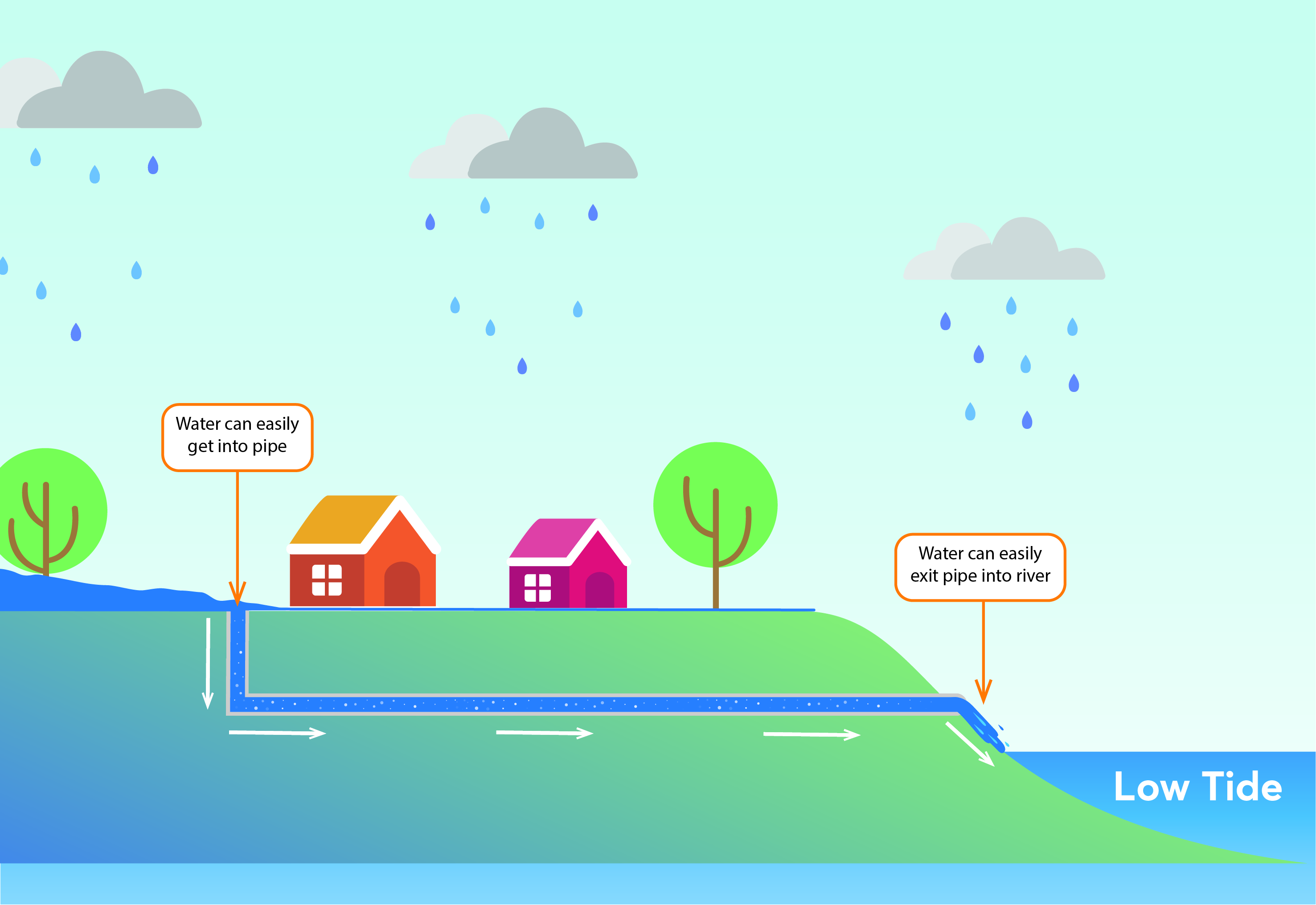
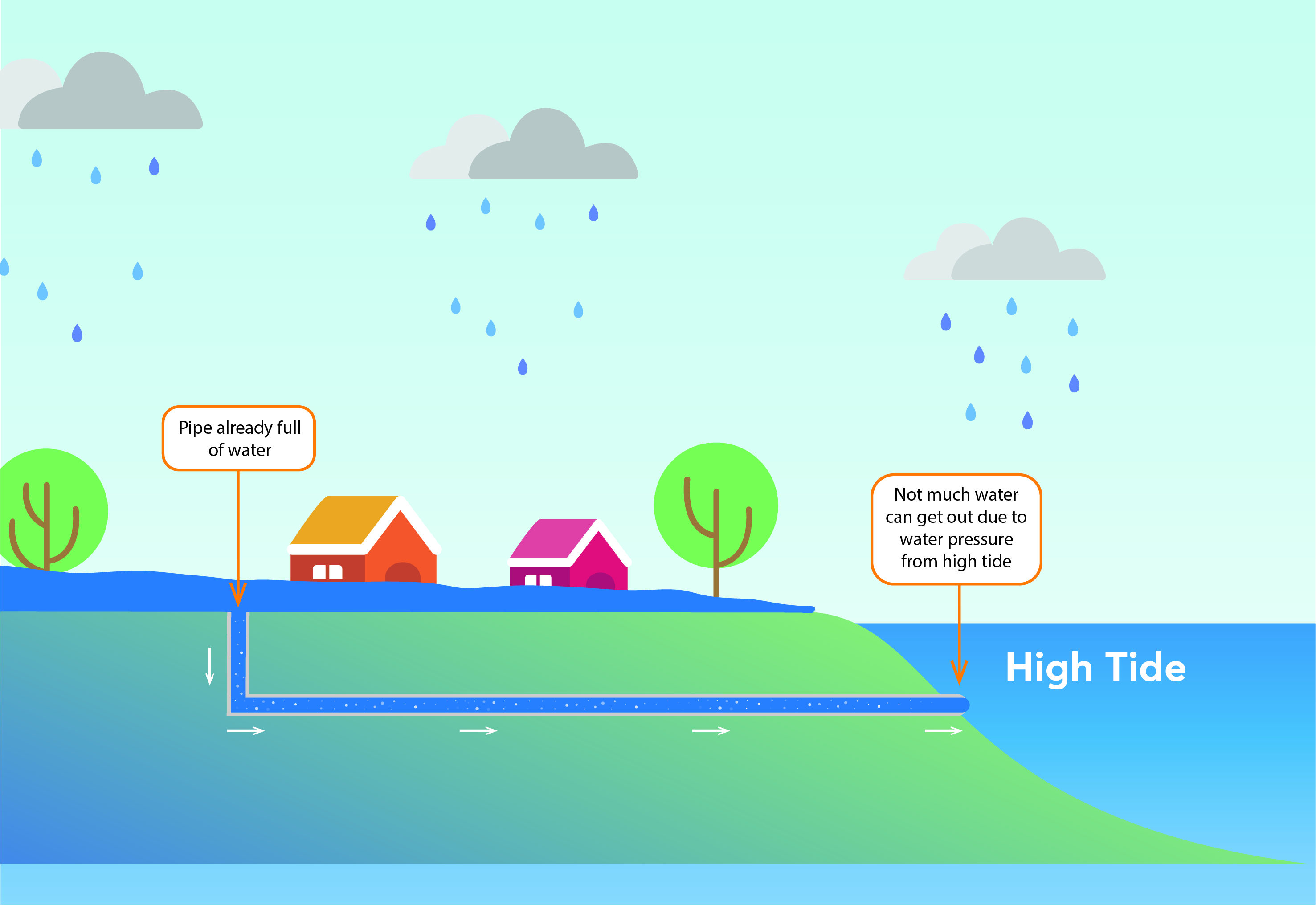
Flooding in the Wentworth Point area is also affected by tidal variation in the Parramatta River. High tides play a part in reducing the amount of stormwater that can be discharged into the Parramatta River. When a storm coincides with a high tide, the drainage outlet is covered by the Parramatta River, due to water pressure, water cannot easily drain to the river and water banks up in the drain and pools at the drain inlet increasing the flood risk.
When the rain is more intense, the nearby Parramatta River or Haslams Creek can rise and send floodwaters directly across Hill Road and into surrounding areas.
The insurance industry already has a good understanding of flood risk across the Parramatta Local Government Area and property insurance premiums are set accordingly.
House prices are largely based on the size and presentation of the house, demand from people wanting to live in the area, and the economic conditions at the time of sale.
However, all landowners with properties at risk of flooding should consider flood insurance and discuss this with their insurance provider.
All responses will be treated confidentially. The information you provide will only be used to improve our understanding of flood risk. Personal contact details will not be shared outside of this project and no information will be disclosed publicly or provided to any other parties.
To book a 15-minute appointment with our Flood Team to discuss this survey and/or flooding at your home, please go to the Flood Talk section of this page.
For help filling out this survey or for more information, please call City of Parramatta on 1300 617 058 and ask to speak with the Haslam Creek project team.
You can also email the team via hillrd@cityofparramatta.nsw.gov.au


